The pace of technological innovation has allowed for greater knowledge of our surroundings, which is why many governments have allocated large sums of money to space research, seeking new techniques and infrastructure that will allow for continued advancement in this knowledge.
Satellite imagery, also known as Earth observation images, photographs from space, or simply satellite photographs, is the product obtained by a sensor installed on board an artificial satellite. It captures the electromagnetic radiation emitted or reflected by a body, which is then transmitted to ground stations for viewing, processing, and analysis.
Types of Images
The types of Earth observation images depend on the type of sensor and the purpose for which the satellite was built. From the first satellite-mounted cameras in the 1960s to the most sophisticated and sensitive hyperspectral sensors available today, there is a wide range of satellite image types currently used in various fields, depending on their spatial resolution and the spectral information they contain.
Furthermore, the availability of free satellite imagery with different resolutions—spatial, spectral, radiometric, and temporal—allows this resource to be used in different areas, at different scales, and for different purposes, making it more accessible.
What are they used for and their applications?
Satellite imagery applications range from:
- Monitoring climate change, fires, and floods.
- Monitoring droughts and determining land use.
- Mapping global oil flows and monitoring oil spills.
- Detecting algal blooms in the ocean.
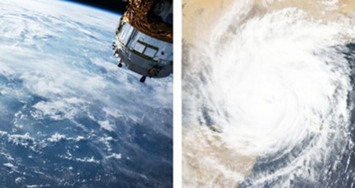
- Monitoring hurricanes, typhoons, and surface temperatures.
- Multispectral vegetation assessments.
There are countless proven and potential applications for satellite imagery, as well as numerous projects for new sensors to be applied not only to monitor our planet but also to map and analyze other bodies in the solar system.
1. Oceanography
A few decades ago, studying the climate and understanding temperature, salinity, ice surface and thickness, wind distribution, and monitoring red tides was unthinkable.
More than 35 years have passed since the first satellite observations of the ocean, and we can measure more and more variables from space. Furthermore, some of these variables now have a historical data series long enough to study climate changes, with a spatial scale and resolution unattainable with other techniques.
The contributions of remote sensing to oceanography have been very important in recent years. Thanks to satellites, it has been possible to estimate:
- The average surface water warming across the planet: 0.17 degrees Celsius per decade.
- The sea level rise is 3.2 millimeters per year.
- The Arctic ice loss is 11.5% per decade.
- The composition of phytoplankton is changing.
2. Meteorology
Satellite imagery is one of the most powerful and important tools meteorologists use; they are, essentially, their eyes in the sky. These images are an input for atmospheric forecasters, providing a clear, concise, and accurate representation of how events are unfolding. Forecasting the weather and conducting research would be extremely difficult without satellites, considering that ground stations are separated by hundreds of miles, so important features can be missed. Satellite imagery helps show what cannot be measured or seen.
There are two types of satellites that orbit the Earth: polar and geostationary.
- Geostationary Operational Environmental Satellites (GOES) remain in a fixed location on Earth's surface and, because the satellites rotate with the Earth, always view the same part of the globe.
- Polar-orbiting satellites, on the other hand, observe a new path with each orbit, so they are not as useful to operational meteorologists because they do not consistently view the same area.
In this regard, there are many different types of satellite imagery. The most useful for meteorologists are visible, infrared, and water vapor imagery.
Visible Satellite Imagery
Visible satellite imagery is equivalent to taking a photograph with a regular camera, requiring light to capture the image. For this reason, these images are only useful when the sun is shining on the area to be photographed. This type of image shows massive thunderstorms. This can be done by observing different structures within cloud masses, which allows one to detect:
- Dark areas in this type of image represent clear weather, where the satellite can see the Earth's surface, while lighter tones indicate cloud cover.
- The circular orientation of the clouds indicates the location of the air surrounding the low-pressure system. These clouds are not as bright as thunderstorm clouds, so the weather beneath them can be expected to be somewhat different.
- The presence of clouds does not always imply precipitation.
- Regarding the visible satellite image, we cannot tell if the slightly lighter clouds are producing rain, as all cloud types are treated equally.
Infrared Satellite Imagery
This type of imagery is useful because it can be taken in the dark; it is extremely valuable, especially in places where there is not much sunlight, such as in the winter months of Alaska.
Infrared measures heat. Dark areas in the images represent warmer temperatures, while light areas represent colder temperatures.
Water Vapor Satellite Imagery
As the name suggests, water vapor imagery shows regions of water vapor located in the upper troposphere. Generally, dark areas represent dry air, while whiter areas show humid air. Dark regions can be associated with air being pushed toward the Earth's surface, where all of its water has condensed and can then behave differently than humid air. Dry air generally represents fair weather, while whiter, moister air shows regions where this moisture could possibly turn into clouds or precipitation.
3. Agriculture
Precision agriculture uses satellite imagery to manage farms with great precision, as it generates a vast amount of information on growing conditions and plant health, which can be used to improve farm efficiency.
These images provide information on:
- Vegetation and soil water.
- Crop conditions, soil properties, and tillage activities.
- Predict harvests.
- Monitor seasonal changes.
- Support the implementation of sustainable development policies.
Satellite images allow farmers to predict key agricultural variables, which are used to rationalize fertilizer use and detect crop anomalies caused by soil, water, pests, diseases, and other factors. Likewise, the images can also be used to predict crop trends and anticipate good agricultural practices and other economic aspects, thereby increasing the profitability of their investments.
4. Oil Sector
Global Oil Flow
Companies supported by the European Space Agency (ESA) use satellite data to map the global oil flow in near real time. The analysis enables producers, operators, and governments to support decision-making.
Crude oil is pumped from underground reservoirs to storage tanks visible from space. These cylindrical reservoirs have lids that float on top of the oil to minimize evaporation losses and reduce the risk of toxic and flammable gases escaping. Earth observation satellites circle the planet with optical cameras that can image these tanks and measure their diameter.
They also carry synthetic aperture radars (SAR) that can detect fluctuations in the height of the lids, allowing the volume of crude oil entering or leaving the facility to be calculated.
Additionally, given that around 65% of the world's crude oil travels by sea, satellites can detect signals from the automatic identification systems on oil tankers and thus track them as they load and transport hydrocarbons.
Oil Spill Monitoring
Oil spill monitoring is a critical component of marine resource conservation. Therefore, reducing the risk of these spills or anticipating their detection is essential for protecting biodiversity and reducing economic losses, both on coasts and in the ocean.
Remote sensing technologies have made significant advances in these areas due to their potential to periodically cover large areas of the Earth's surface. While in situ pollutant detection sensors, such as floating buoys, exist, only satellite imagery can provide a comprehensive view of the affected area, making it a very useful tool for providing an integrated response to a potential emergency.
There are numerous satellites, both optical and radar, used for oil spill detection and monitoring. SAR images have important aspects that differentiate them from optical images. The fact that they operate in the microwave region of the electromagnetic spectrum means that cloud cover is not a problem for viewing the Earth's surface. Furthermore, since it is an active sensor, meaning it generates and emits its own energy, it works independently of sunlight, so it can take images both day and night.